Preservation Efforts on Jehossee Island
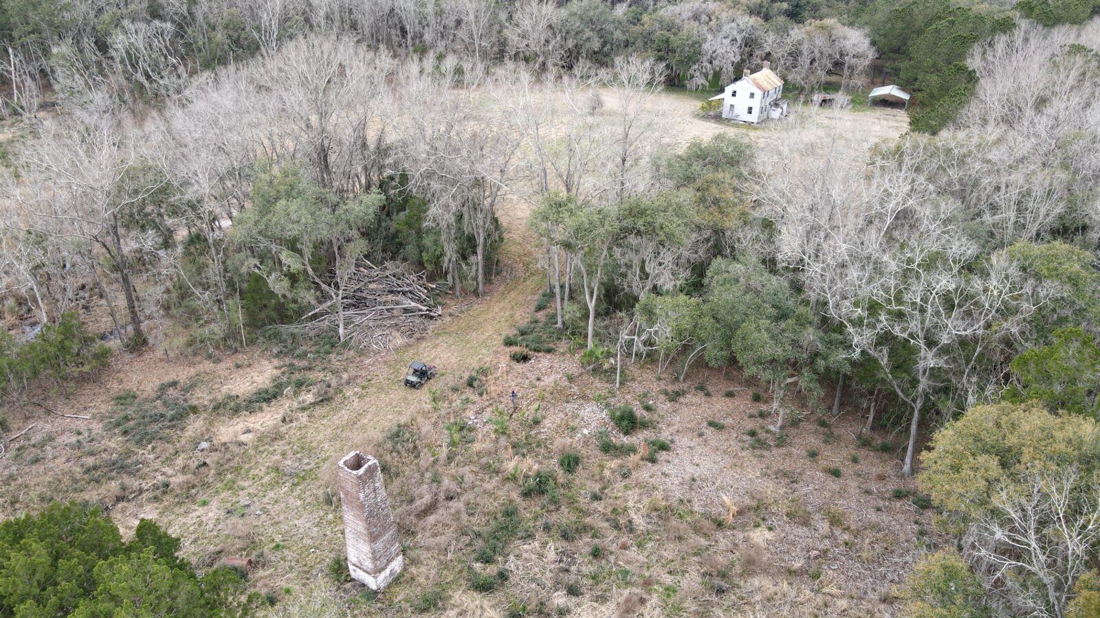
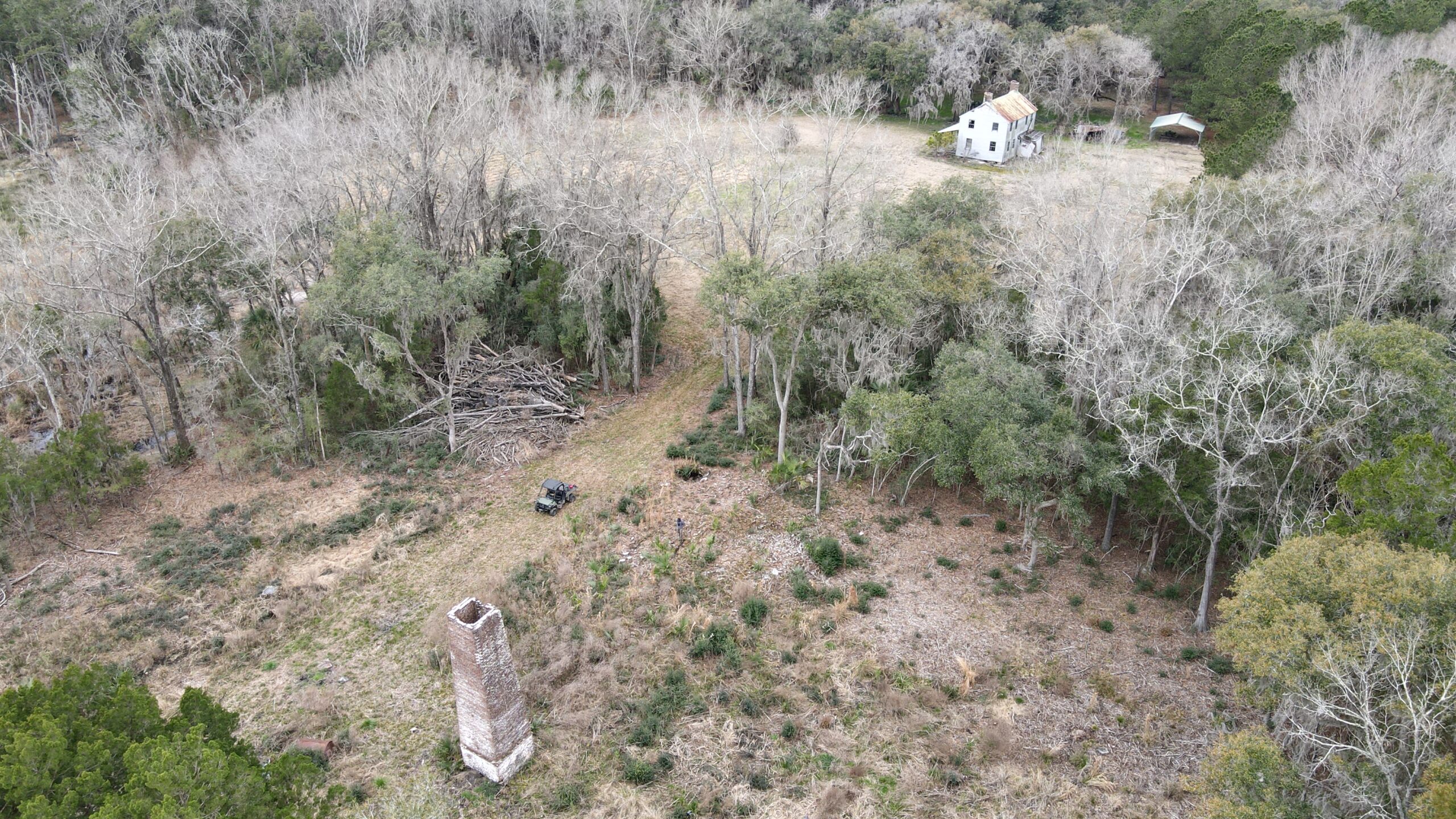 Drone photography of the c. 1830 Jehossee Island overseer’s house and rice mill complex taken in March 2021. Courtesy of Brent R. Fortenberry, Ph.D, RPA.
[envira-gallery id=”6139″]
Top left: Map of resources identified by the S.C. Institute of Archaeology and Anthropology reconnaissance in 1986; top right: aerial view of the S. Edisto River near Jehossee Island; bottom: Overseer’s House and Rice Chimney in March, 2021, courtesy of Brent Fortenberry, Ph.D RPA.
The island’s history spans centuries with archaeological evidence of long-term Native American occupation long before European settlers and enslaved Africans and African Americans arrived c. 1685. Historical records indicate the island’s name evolved and varied throughout its history. On a map dated 1695, Jehossee is referred to as “Chebash,” which may have been a derivative of an earlier Native American name. By 1706, the island was referred to as “Johoowa,” then “Johassee” by the time of the Yemassee War in 1715, eventually transitioning to “Jehossa,” and finally “Jehossee” by the end of the 18th century.[1] Jehossee was first recorded as a working rice plantation in the 1760s, corresponding with the period of time when rice was on the rise as a major export industry in the Carolinas. Jehossee was solidified as a productive rice plantation under the long-term ownership of two of the most affluent and politically-powerful families in the Lowcountry’s history: the Draytons and the Aikens. Jehossee was owned by the Drayton family from 1776 until 1824, and was then property of Governor William Aiken and his descendants from the 1830s until ownership was transferred to the USFWS in the 1990s. Charles Drayton, who also owned Drayton Hall Plantation, wrote extensively about day-to-day management of Jehossee in the late 18th and early 19th century in his diaries, although he likely spent little time there. Drayton’s entries provide the most detailed, surviving accounts of daily life on Jehossee. For example, we know from his writings that, in addition to rice, enslaved people on Jehossee grew corn, potatoes, indigo, and cotton.[2]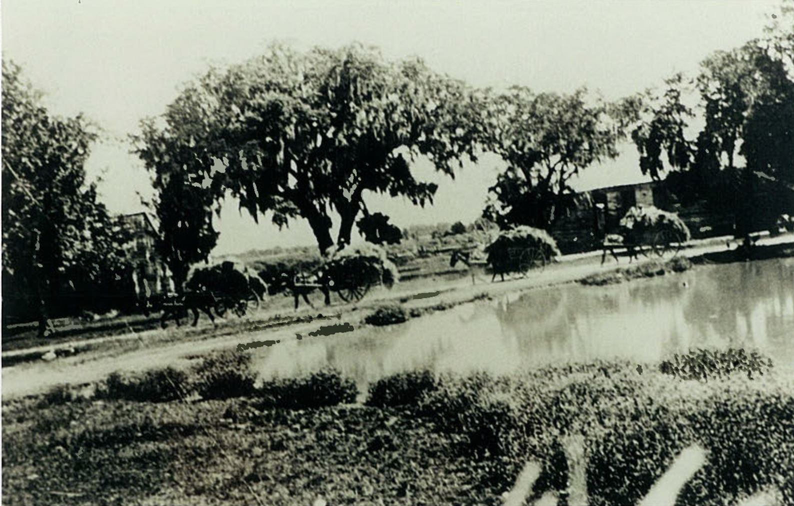 “Carting Sheaves of Rice.” Photograph courtesy of the Chicora Foundation and Lindsay Oswald; originally reproduced in Phillips 1929)
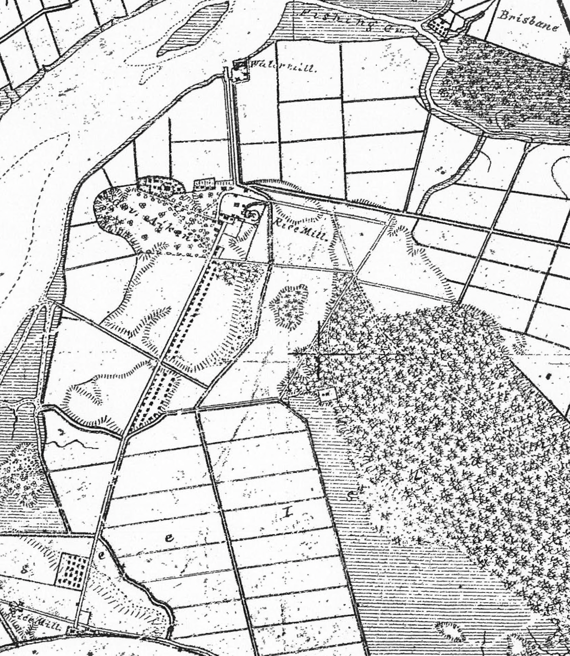
US Coast Survey, 1856-57
Highly labor intensive, tidal rice cultivation relied on trunks to direct water flow from freshwater rivers to rice fields via canals painstakingly forged by enslaved workers—a truly herculean task. Rice production and processing at this level necessitated a large and complex infrastructural system including dikes, trunks, and canals, many of which remain largely intact on Jehossee today. Former rice fields and systems have been adapted as managed impoundments by the USFWS for wildlife and water management on the island. The continued existence of the 19th century historic agricultural landscape and infrastructure is dependent upon routine maintenance and frequent rehabilitation. Jehossee was the pinnacle of tidal rice production in the Lowcountry in the 19th century, the success of which was built on the backs of one of the largest enslaved populations in the South. At peak cultivation between the 1830s and 1860s, an estimated 700-900 enslaved persons lived and labored on Jehossee Island.[6] 19th century written accounts and a site plan completed as part of the 1856-1857 U.S. Coast Survey indicate the presence of an extensive village built by and for Jehossee’s enslaved population, including a recorded 84 wood frame houses, a church, a hospital, a store, and an overseer’s house, among other industrial structures associated with rice cultivation.[7] Shown on the map above, the extensive, double-to-triple row of structures comprising the enslaved village is a rarity. Unfortunately, only brick from former chimneys remain as above-ground evidence of this settlement, pointing to the significant potential for archaeological study to better understand the lifeways and resources of Jehossee Island’s enslaved population. ONGOING PRESERVATION EFFORTS[envira-gallery id=”6141″]
Left: double oak allee on Jehossee Island; right: Rice Chimney site, courtesy of PSC Staff.
Jehossee Island has been uninhabited and relatively undisturbed for more than half a century. The USFWS has been a responsible steward of this landscape for nearly 30 years, but by the time the island came under federal ownership in 1993, the Overseer’s House and Rice Chimney had long been out of use, already the victim of decades of neglect and exposure to harsh elements. The vulnerability of Jehossee’s historic resources has been exacerbated by successive and worsening hurricane seasons and the ever-increasing threat of sea level rise, ultimately leading to the launch of a coordinated effort to ensure their preservation. In 2018, the Preservation Society and our partners at the U.S. Fish and Wildlife Service, the ACE Basin Task Force, Drayton Hall, the Charleston Museum, and Historic Charleston Foundation joined forces to identify preservation priorities and necessary funding, beginning with the Overseer’s House and Rice Chimney site. Post-hurricane federal funding following the series of storm events that impacted the Lowcountry from 2015 to 2018 was key in providing for the large-scale clean-up of the site, protecting the house and chimney from further damage from encroaching vegetation. Next, the group engaged historic preservation and vernacular architecture professor and scholar Brent R. Fortenberry, PhD of Tulane’s School of Architecture to spearhead documentation efforts. Dr. Fortenberry specializes in the vernacular architecture of the British Atlantic world and digital documentation of associated resources.[envira-gallery id=”6142″]
Digital documentation of the Jehossee Island Overseer’s House courtesy of Brent Fortenberry, Ph.D RPA.
In March 2021, a field team comprised of Dr. Fortenberry, restoration contractors Thomas Graham III and Beekman Webb, and structural engineer John Moore, undertook a comprehensive documentation and conditions assessment on Jehossee Island. The team completed analog and digital documentation of the Overseer’s House and Rice Chimney site and a preliminary GNSS survey of the former Drayton-Aiken Plantation House complex. Information gathered on-site directly informed a subsequent submittal to the State Historic Preservation Office (SHPO) outlining a plan for stabilization and phased rehabilitation of the Overseer’s House. With SHPO approval and the support of generous donors, the project team successfully stabilized and began rehabilitation of the c. 1830s Overseer’s House in fall 2021. To date, the scope of work has included major foundation and siding repairs, repointing of chimneys, and in-kind replacement of the failing roof and window sashes. NEXT STEPS[envira-gallery id=”6143″]
Left: documentation of brick ruins at the former rice mill site on Jehossee Island, right:aerial view of partially flooded former rice fields, drone photography courtesy of Brent Fortenberry, Ph.D RPA.
Beyond rehabilitation of the Overseer’s House and Rice Chimney complex, there is tremendous opportunity for site survey, laser scanning, and archaeological study across Jehossee Island’s sprawling landscape. This progressive analysis has the potential to reveal new insight into the daily lives and material culture of enslaved Africans and African Americans, whose lives are severely underrepresented in the interpretation of plantation sites across the Lowcountry and beyond. We look forward to sharing more on this project as documentation and preservation efforts continue. To learn more about Jehossee Island, please utilize the resources below, or email the Advocacy team at [email protected]. To support the PSC’s preservation and research initiatives, you can give a gift online or contact the Advancement Department at [email protected]. RESOURCES To learn more about the history and landscape of Jehossee Island, the PSC recommends the following resources: Archaeological and Historical Investigations of Jehossee Island, Charleston County, South Carolina, Chicora Foundation, Inc., 2002. Imagining Jehossee Island Rice Plantation Today, International Journal of Heritage Studies, Antoinette T. Jackson, Ph.D., 2008. Plantations, Planning & Patterns: An Analysis of Landscapes of Surveillance on Rice Plantations in the Ace Basin, SC, 1800-1867, Clemson University Tiger Prints, Sada Stewart, 2019 [1] Chicora Foundation, Archaeological and Historical Investigations of Jehossee Island, Charleston County, South Carolina, 2002, p. 33 (Thorton-Morden map showing “Chebash” and vicinity of Jehossee Island, 1695). [2] Chicora, p. 53. [3] Drayton Hall Interiors 20(2), Research News: Learning from Jehossee, Summer, 2001. (Chicora, p. 53) [4] Chicora, p. 55, 162. [5] Chicora, p. 201. [6] Dr. Antoinette T. Jackson, Imagining Jehossee Island Rice Plantation Today, International Journal of Heritage Studies, University of South Florida, 2008, p. 141. [7] 1856-1857 U.S. Coast Survey