Media Coverage
Charleston County offers new Highway 41 plan after Phillips Community threatened
preservation-admin , March 4, 2021
View the original Post and Courier article here
Charleston County has unveiled a new, $187 million road plan for S.C. Highway 41 in Mount Pleasant, one aimed at balancing the need to address traffic with concerns about which community will bear the most impact.
Compared to the previous plan, the new one would have a smaller impact on the historic Phillips Community, which was settled by Black residents after the Civil War, and a larger impact on the Dunes West subdivision.
The county has been wrestling for five years with plans for the two-lane road, which Mount Pleasant’s rapid population growth and development has overwhelmed with traffic.
In 2020 the county came out with a controversial $125 million plan to widen the road to five lanes through Phillips. The county received nearly 3,000 comments from the public, and opinion was about evenly split.

Due to the impact on Phillips, the plan was denounced by an unusually broad coalition of opponents including The Coastal Conservation League, Historic Charleston Foundation, Charleston Preservation Society, Save Shem Creek, Charleston Moves, Lowcountry Land Trust, East Cooper Land Trust, Southern Environmental Law Center, Center for Heirs Property Preservation and the Charleston Trident Association of Realtors.
“What we’ve done since has been driven by an extraordinary outpouring of comments from the public,” said county consultant Rhett Reidenbach, with the Reveer Group.
Reidenbach said he’s never seen the level of public comment that the Highway 41 plan received.
The new plan calls for Highway 41 to be widened to three lanes through Phillips — two driving lanes and a center turn lane. As a result, only two vacant properties will lose land to the road widening.
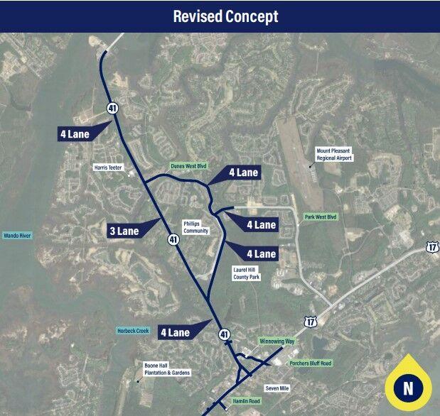
An overview of Charleston County’s new plan for Highway 41 in Mount Pleasant. Provided/Charleston County
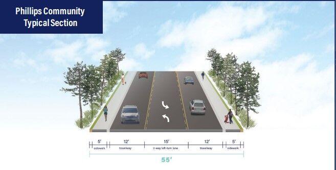
Charleston County’s new plan for S.C. Highway 41 in Mount Pleasant calls for three lanes through the Phillips Community. The road is currently two lanes. Provided/Charleston County
“They’re going to take the traffic away from Phillips and go around Phillips,” said community president Richard Habersham. “That’s all we were asking for.”
The rest of the nearly 5-mile stretch from the Wando River to U.S. Highway 17 would be four lanes, as would Dunes West Boulevard, which would have a 35-mph speed limit, a planted median in the middle and a bike/pedestrian path on the side.
A new connector road would also be built, to avoid having to widen Bessemer Road, which is lined with recently-built homes.
County officials said the right of way along Dunes West Boulevard is large enough to accommodate the widening plan, and the road is bordered by properties controlled by the homeowners’ association.

Charleston County’s new plan to address traffic on S.C. Highway 41 in Mount Pleasant calls for widening Dunes West Boulevard to four lanes. Provided/Charleston County
“What we realized is, if we don’t widen Dunes West Boulevard to four, lanes there will be a critical piece of infrastructure missing,” Reidenbach said.
Parts of the new plan are similar to the county’s previous runner-up plan, which was known as Alternative 7A. That plan was opposed by many residents of Park West and Dunes West because it directed traffic through part of those subdivisions.
Reidenbach said the plan will improve safety as well as traffic flow, and could be underway in 2025. By 2045, he said, Highway 41 will be carrying an estimated 55,000 vehicles daily.
The county’s website for the road project is hwy41sc.com.
Charleston County Council members spoke favorably about the plan, except for Councilman Dickie Schweers, whose district in Mount Pleasant.
“I’m not ready to commit to this,” he said.
Councilman Herb Sass, who also represents part of Mount Pleasant, said he’s “very excited” about the plan, and Council Chairman Teddie Pryor said he was “well pleased.”
Next, the county plans to present the detailed plans to the town of Mount Pleasant at a Town Council meeting March 9 and also to individual communities.
Charleston County Council is expected to vote on proceeding with the plan March 18.
In addition to widening the highway, the new version calls for a massive redesign of the intersection of Highways 41 and 17. By 2045, U.S. 17 is expected to carry 90,000 vehicles daily near that intersection, which Reidenbach said is comparable to traffic on Interstate 526 east of the Cooper River.
If the new road plan moves forward, there would be a four-lane path from Highway 17 to the Wando Bridge. Across the bridge, in Berkeley County, is Clements Ferry Road, which is in the process of being widened to four lanes.