Advocacy Alerts
Keeping History Above Water Conference Highlights
preservation-admin , June 14, 2022
Charleston is not alone in our battle with rising seas. We are among dozens of other coastal communities trying to learn to live with water, while maintaining a special sense of place and livability for residents. This is why we feel collaboration is essential as we chart a course for the future, so we can work together on solutions that benefit everyone.
Conferences like Keeping History Above Water offer important opportunities for conversations on collective experiences and to showcase innovative resilience approaches across the country. PSC Director of Historic Preservation, Erin Minnigan, was pleased to attend this year’s conference in Norfolk, VA and represent the Charleston community.
Each year, Keeping History Above Water selects a host city on the forefront of resilience planning for historic resources, and Norfolk is no exception. Located on the Chesapeake Bay in Virginia, the City of Norfolk is one of the most progressive municipalities in developing regulatory and technical strategies to address changing climate conditions. While the conference sessions focused on the layers of approach to tackling rising seas in Norfolk, there was also a strong emphasis on relevant federal policy and programming for treatment of historic buildings, as well as disaster preparedness and response. Finally, case studies presented on creative strategies taken to mitigate flood risk helped serve as models for other communities facing similar challenges.
See below some of the conference highlights:
Building Resilience in Norfolk’s Chesterfield Heights Neighborhood
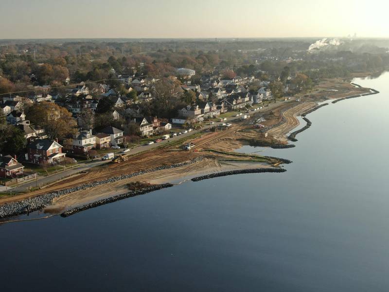 Aerial view of work underway to construct a living shoreline and berms along the banks of the Elizabeth River adjacent to the Chesterfield Heights neighborhood
Using grant funding from the US Department of Housing and Urban Development (HUD), the City of Norfolk undertook a massive effort to improve resiliency of the historic Chesterfield Heights neighborhood, which is listed on the National Register of Historic Places. Since 1930, there has been a recorded 14-inch rise in sea level in this area, causing many of the homes to experience regular flooding episodes. The project included implementation of natural and hardscape measures, such as a living shoreline, earthen berm, upgraded drainage network, and pervious pavers throughout. To help facilitate water storage, the City built a new “Resilience Park” that doubles as a space for community gathering and recreation.
- City of Norfolk Ohio Creek Watershed Project
- Norfolk Neighborhood Gets a boost from Sea Grant and HUD
CIVIS Analytics – Norfolk Flood Risk Learning Center
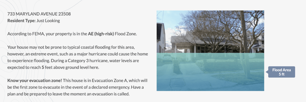 Example report generated by the Norfolk Learning Center to visualize flood risk
Community engagement is a major priority in the City of Norfolk’s approach to resilience planning. Making climate change data accessible and creating tools to help property owners in flood prone areas navigate their options is one way the City is achieving this goal. The Flood Risk Learning Center developed by the data science firm, Civis Analytics, helps residents visualize flood risk to their property based on their home’s current elevation and FEMA data, empowering them to make informed decisions to protect their property.
- Norfolk Flood Risk Learning Center
- What’s Your Home’s Flood Risk? Norfolk Launches Interactive Tool
National Park Service’s Climate Change Response Program
New federal guidance was presented on response and mitigation following a disaster, that are designed to provide historic preservation leaders with information about how to work with federal agencies, including the National Park Service (NPS) and Federal Emergency Management Agency (FEMA). The document includes roles and responsibilities of the various agencies, guidelines on how to best prepare, respond, and recover to disasters, and most importantly, post-disaster funding opportunities available for historic and cultural resources.
- Before and After Disasters: Guidance for State and Tribal Historic Preservation Leaders on Working with FEMA, NPS and Other Federal Agencies
- National Park Service Climate Change Response Program
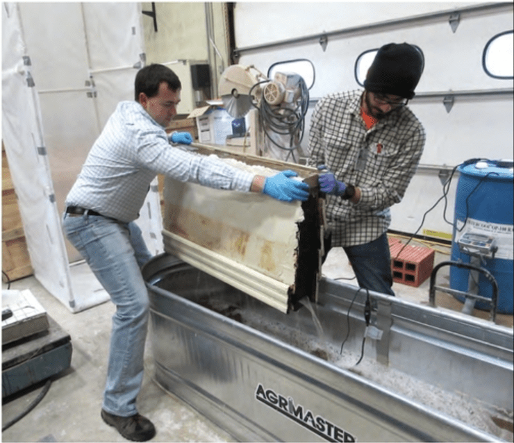 Testing resilience of wood frame construction to flood conditions in a lab
Following the publication of NPS’s Guidelines on Flood Adaptation for Rehabilitating Historic Buildings (2019), the agency went on to test the resilience of historic building materials to flood conditions. Initial findings show traditional building materials are inherently more resilient to repeated inundation than modern construction. Building Resilient Solutions is conducting similar efforts locally in Norfolk and has constructed the first dedicated lab in the US for testing the resiliency of traditional materials and techniques during and after flood events.
- Testing the Flood Resilience of Traditional Building Assemblies
- Flood Resilience of Traditional Building Materials
- Building Resilient Solutions
Envision Resilience
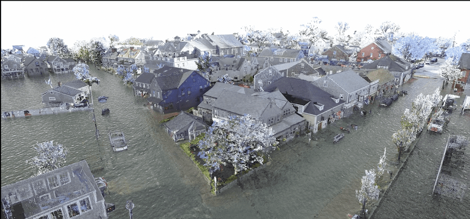
Example 3D model created by Envision Resilience depicting future sea level rise in Nantucket
Envision resilience brings together technology and people to chart a course for the future of communities threatened by sea level rise. Laser scanning and 3D modeling are used to visualize how rising seas impact our cultural heritage, and to help inspire the development of adaptive strategies. Current study areas include Nantucket, MA and Narragansett, RI, but we hope this collaborative model between citizens, experts, and students could be replicated in other coastal communities like Charleston.
RISE Resilience Innovations
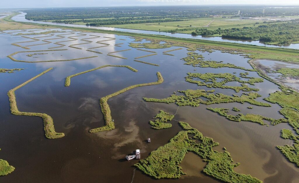 Adaptive infrastructure installed by RISE Challenge Winner, Natrx
The Rise Challenge Model is a pioneering approach that makes long-term, innovative resilient solutions a reality. Working with stakeholders across the public and private sectors, Rise identifies some of the biggest problems affecting coastal communities, and hosts an annual “Challenge,” soliciting physical, scalable resilience solutions. Challenge winners are then provided catalytic funding to deploy their solutions within a local pilot community. One example of a winning project is Natrx Adaptive Infrastructure, which combines environmental data intelligence with software and advanced manufacturing to deliver nature-based solutions to the infrastructure market.